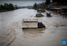
Although Chure degradation has been identified as a major national problem, its continued exploitation has not been stopped due to the weakness of the state. Chure devastation has affected a large swath of population living in the Terai-Madhes region and other parts of the country, including Udayapur.
Displacement of human settlements
Ninty-year-old Ganesh Prasad Subedi of Kheratola Sundarpur- 5 has been living as a refugee on the premises of Bailey’s school. There are seven members in his family. His family became homeless after flood in Triyuga, the largest river in Udaiyapur, washed away his home and land. He has been working as a priest at a local temple to earn his livelihood. “In have four bhigas of land in my name. But the entire land is covered with sand. And the land ownership certificates (Lalpurja) does not feed us,” says Subedi.

Laxmi Chaudhari, 48, a resident of Chaudandigadi muncipality-5 Sundarpur is also living as refugee after her home and 6 Bhiga land were destroyed by the floods in 2045 B.S. “Triyuga River made us refugee,” says Cheru Chaudhari, 65, of Sundarpur-5, showing the landownership certificate of 1 bhiga 18 katta land. Chaudhary’s family lives in a forested area in Dhamichanp under Chure.
The list of such displacement is long. Floods in the Triyuga River, which is the center of the mountainous region of Mahabharata, inundated Kheratol, Jutpani, Miyatol, Sundarpur and other villages in Sundarpur. One hundred thirty six families were displaced by floods in Kheratool and Sundarpur. One thousand five hundred bighas of land were turned into river beach. Due to the flood, one hundred and seventy-seven families were displaced from dozen more villages including Dhelachauri, Ajagara, Devnagar, Dhatitol, Andheri, Bakaina and Khairaha of Hadiya VDC.
Most of the displaced families have encroached Chure forests for living. In order to earn their livelihood, some of the victims have gone to Assam state in India. Most of the displaced families only have land in the papers. This was the consequence of Chure destruction and other environmental degradation since 2030 BS. Frequent landslides and floods have turned 11,396 hectors land into river beach. As a result of unchecked exploitation of Chure, water resources started drying up causing a serious drinking water problem in the human settlements. The settlements of Belaka, Chaudandighadi, Triyuga and Katari municipalities were mostly affected.
Volatile Chure
According to the ‘Chure-Tarai Madhes Conservation and Management policy’ (2074), Chure is made from the Thagar deposited by the rivers flowing through the Himalayas and the Tibetan Plateau. The youngest hill formed by the deposition of the river products around 40 million years ago is the Chure range. The Chure range which is extended from Indus river of Pakistan in the West and Bharamaputra of India in the East is also called “Shivalik”. In most of the places in the Tarai, Chure is located in the northern hills and lower to the Mahabharat area. This area is made up of the fluvial sedimentary rocks which is not fully adjusted, and all the rivers and rivulates from Mahabharat range flow from this area to the Terai. This naturally very sensitive area extends into 37 districts from Ilam in the East to Kanchanpur in the West of Nepal.
In Nepal, it starts from 120 meters above the sea level and rises to 1972 meters. It accounts for 12.98 percent of the country’s total land area. In most places, the Terai lands are crossed and the elevated terrain and the Mahabharata region fall as the last mountain to be found.
According to Chure scholar and forest expert Netra Regmi, land cover has decreased due to the destruction of forest in the Chure area, which is a volatile terrain mixed with immature stone and sand. Because of deforestation and reforestation, the sloping and weak terrain of the soil has reduced the ability of the soil to absorb water. This has resulted in the increase of soil erosion. Rivers and drains flowing due to erosion have increased the risk of excessive sand and sedimentation in the river coastal areas.
According to President Chure-Tarai Madhes Conservation Development Committee, Chure hills, which have an area of 2, 063 sq km, are occupied by 8 percent of the land of Chure hill, 21.7 duns (inner Madhes), 6.5 Bhava Terai and 36.8 per cent mid-hill. Chure areas include Chure hills, inner Madesh land, duns and rivers. The data from the Division Forest Office, Udaipur shows that there are 49,435 households in Chure area of the district, with a total population of 226,766.
In the Triyuga, there are 19 streams and rivulates that flow through Chure. According to Bishnu Dev Yadav, Division Engineer at Khando River Control Office, Rajbiraj, who prepared DPR for controlling the Triyuga River, said the sand deposited by the flowing cannels has raised the surface of human settlement and cultivable land by an average of 15 cm of sand over the settlements and cultivable land.

According to Former member of Chure Development Committee and forest expert Dr Nagendra Prasad Yadav, the rivers coming out of Chure are volatile because as the Chure is weak made from clay, leaf cliff. Due to the continuous exploiting in it, the risk of floodwaters has increased as the rivers change the stream. The Chandra nahar, which was built in 1979 on the Triyuga River and started distributing water since 1985, also caused thousands of cultivable land into river and hundreds of families were displaced. Due to the increasing amount of sand on the surface of the river due to the canals, 14 villages of Triyuga, Chaudandigarh and Bel Municipality of Udaipur have been converted into riverbed.
According to a study by Land Rights Forum, about 10,000 bighas of cultivable lands were turned into riverbed while Triyuga was changing its course. Central Secretary General of the Land Rights Forum Bal Bahadur Tamang said that rivulets have done a good to Saptari but it has not benefited Udayapur except ofr Seti Bagar.
Chief of Triyuga Municipality-2, Ghaman Singh Khatri said that the settlement was displaced due to deforestation and exploitation of the forest materials smuggling with the involvement of community forest officials.

Crusher industries are being operated without meeting the criteria introduced in 2070. Excavation of riverbed materials is underway in Udayapur through a contractor. Unscientific excavation has increased the risk of weakening embankments and physical infrastructure. Chure, Terai Madhes is also an important area in terms of biodiversity. Of Nepal’s 118 ecosystems, 14 is located in Chure Hills, and 12 in the Terai Madhes area. The destruction of Chure has also posed a serious threat to the survival of biodiversity.
According to President Chure-Tarai Madhes Conservation Development Committee, of the total 2,063 Square Km area of Udayapur, 34.9 percent is Chure hill, 21.7 is Dun (inner Madesh), 6.5 is Bhawar Terai and 36.8 percent mid-mountains. Chure areas include Chure hills, inner Madesh, Dun and river basins.
Forest encroachment
Udayapur forest area is one of the most affected districts. The aerial picture of 1978-79 showed that the district contained 68.34 percent forest, while the statistics published by the Forest Research and Survey Department in 1994 showed that it was 65.27 percent. Excluding other wood and butane areas, it comes in at 64.83 percent. During the nearly four decades between 1978 and 2016, 9,338.7 hectares of forest area was encroached. Forest encroachment has been found to be high during political change. The encroached land has a population of 755 households.

In Udayapur, community forest was formed and transferred since 2049 BS. According to the Division Forest Office, Gaighat, there are 347 community forests in the district. Of which, there are 255 community forests, one Chakla and four religious in the Chure area. In Chure area, the community forest covers an area of 66,739 hectares of land.
However, Chure is being encroached by the local community forest consumers when they are not responsible for the conservation and management of forest. In the recent past, community forest groups have not shown much interest in conserving forest areas. Assistant Forest Officer Jwageswor Shah, Division Forest Office, Gaighat said the community forest consumer group is business-oriented.
In the Chure and Mahabharat Mountains series of Udayapur, 26,898 trees have been cut in three years in the name of road and hydropower development. Out of the community forest area, 8,393 trees have been felled. According to Kaushal Babu Basnet, president of the Community Forest Consumers’ Federation of Udayapur, local representatives, and state have not been shown seriousness and responsibility regarding development through forest.
Chief of the Division Forest Office, Udaipur, Naresh Thakur has accused the forest officer of being against development, while prohibiting the use of excavator in the forest area. Some local bodies, drinking water and police physical infrastructure are also in the forest area.
Prosperity factor
President Chure-Tarai Madhes Conservation Development Committee executive member Bidur Bharti said that the army has been conserving and rebuilding the natural lake for forest and land conservation in the border areas of Udayapur and Siraha for four years.
Baldev Chaudhary, chief of the municipality, said that the municipality is preparing to move ahead with a master plan to make the Triyuga River more usable for the Triyuga Valley. The master plan also includes collecting water from the Chure River, dam, at a distance of 85 km.
Chure expert Dr. Nagendra Yadav says that it will cost millions of rupees a year to construct sand embankments. He recommends making river system perfect. . Every year, the surface of the river is made deep by embankment. Increasing the flow of water in the river pushes it to the same depth and the embankment collapses. “Chure origin river system should made perfect which needs correction at grassroots level,” he said.


