Most of the settlements of Hetauda in Makawanpur district are facing the risk of soil erosion and landslide. Five wards of Hetauda Sub-Metropolitan City that are across Rapti River and four wards of Manahari Rural Municipality—all these places lie in the Chure region—are exposed to the risk with the onset of monsoon.
Wards 7, 8, 12, 13, and 14 of Hetauda and 1, 2, 3 and 4 of Manahari become vulnerable to landslide after the rainy season starts every year. Chure region remains a challenge for this district because of its topographical structure. Of the total area, 48.75% is covered by Chure region.
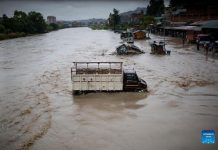
More than 300 acres of fertile land in Makawanpur is converted into river basis every year due to brooklets of Chure, while more than a hundred families rendered landless. The lands alongside the river turn into bank due to rainfall, but the locals try to revive the land to make it arable again in two to four years. Umakant Aryal, a hundred years old resident of Hetauda-13, has witnessed highs and lows of Chure and its brooklets many times. Recalling the huge floods of 1993, 2004 and 2016 in the brooklets, he says, “People have to suffer the trouble due to flooding every year. But I haven’t seen the flood as devastating as that of 1993.” Although there is no official record of the total loss that year, the elders along with Aryal estimate that there were more than 100 casualties. It is not that the locals want to live in vulnerable area but they have no choice. Shankar Thokar, who lives in Manahari-3 Hadikhola of Makawanpur at Masine brooklet bank, says that the flood is giving them trouble every year.
“Even the small rainfall causes flash floods, and it gets dried up immediately as the rain stops. We are facing a lot of trouble. A dam was constructed in the past but was washed off by flood. We had to run for life as well,” said Thokar. “We don’t have land elsewhere. This house also belongs to landlord. We don’t know what to do if this house is also swept by flood. We are daily wage earners; sometimes we catch fish for living.”
Thokar is only a representative of scores of people troubled by this issue. Most of the locals here live in constant fear as the rainy season begins every year. The people living on the banks of brooklets say that they become anxious during monsoon season fearing that the flood and landslide would hit their houses anytime. The brooklets have affected Bakaiya and Bagmati Rural Municipalities of eastern Makawanpur as well. Although the exact number of brooklets is not confirmed, District Soil Conservation Office Makawanpur estimates that there are more than a hundred of them. Water Induced Disaster Prevention Division Office also has not updated the statistics of brooklets in the district.
The earthquake of 2015 has increased the vulnerability of the area, study suggests. According to a study conducted using Geographical Information System (GIS), a total of one thousand and sixty-three landslides, including small and big ones, have occurred in Makawanpur. From the aspects of soil erosion and landslide, only 15,660 hectors of land, which accounts for 6.49% of the area of Makawanpur, is deemed safe from brooklets and landslides. 74,132 hectors of land, i.e. 30.73% of total land is always at risk in terms of floods and landslides. Chief of District Soil Conservation Office, Mr. Raju Dahal say 63% or 51,000 hectors of total land is at high risk of soil erosion.
Manahari, Hadikhola, Padampokhari, Churiyamai, Hatiya, Chhatiwan, Phaparbari, Raigaun and Dhinyal are parts of Chure region. The forests in these places, whether owned by the government or conserved by the user groups, are the ones that have been destructed the most. Experts agree that rate of soil erosion and destruction will increase in Chure region.
Though governmental and non-governmental organisations are working in Chure Shivalik region, they have not been that effective. Every year, there is 2.75% of destruction and soil erosion in Chure region that runs along from Mechi in the East to Mahakali in the West. The DDC concluded the fertile land of Terai districts, also known as granary of the country, would turn into sand dunes in the next 25 years if measures were not taken to stop the soil erosion at the current rate.
President Chure Conservation Programme has been implemented for past few years as part of the bid to conserve Chure. Soil Conservation Office started the campaign to conserve the Chure region from 2010. It was from fiscal year 2014/15 that the risk mitigation programme of Chure and brooklets was initiated. Makawanpur Division Chief Basant Gautam explained that a total budget of NRs 49.5 million was spent in fiscal year 2014/15, NRs 48.1 million in 2015/16 and about NRs 70 million in each fiscal year 2016/17 and 2017/18.
The programme has given momentum to Chure conservation activities. Some activities have been conducted in some areas of Makawanpur including Bakaiya Rural municipality. Chure region that extends 885 km long, and encompasses 34 districts of Hilly and Terai region. It is the youngest and smallest hill among the mountain range, and because of the unstable and sloppy soil this region suffers from soil erosion and landslide during monsoon season. Since Chure region covers 12.7% of the total area of the country, its destruction is not only limited to itself, but also has caused destruction of fertile soil in Terai.
Out of total area of 242,600 hectors of land in Makawanpur, 413,038 hectors of land are arable, but only 365,042 hectors of land are being used for cultivation now. Then District Agriculture Development Office of Makawanpur states that 185 hectors of arable land (0.5%) in Makawanpur are at risk of flood. From 1964 to 1979, deforestation and land destruction happened at the rate of 18,800 hectors per year. Chure region is made up of slope and soft soil, gregarine and sand, which puts it at risk even without human activities. And now, with the increase in human activities, and road and other infrastructure development, the rate of soil erosion is increasing in Chure region.
The fate of fertile land of Terai region depends upon the age of Chure, so the experts say the sustainable conservation, preservation and development activities should be conducted through one-window system. The growing worries due to brooklets are primarily the consequence of overexploitation of Chure, says Bijay Singh Danuwar, who holds a PhD on Chure. He said, “While the highway expansion will cause some exploitation of Chure, the expansion of human settlement will only exacerbate the problems.” He further said that the dual policy of the state has caused the uncertainty in this matter. He opines that the highway has caused several cracks in Chure region. Dr Danuwar emphasizes that there should be a comprehensive geological study of Chure while constructing the highway so as to minimise destruction of Chure. “Unscientific agricultural system coupled with lack of proper land utilization and management has put Makawanpur at the risk of natural calamities such as landslide and soil erosion,” he said.
Makawanpur ranks second only to Solukhumbu in the country in terms of soil erosion and landslide vulnerability. After the GIS study, Makawanpur Soil Conservation Office has notified that Makawanpur should be on high alert. Because the important measures of soil conservation have not been embraced, large area of Makawanpur are at high risk of landslide. GIS study has revealed that the number of landslide in Makawanpur of area less than one hector is 751, while the number for area of between one to two hector is 156 and for area of between two to three hectors is 61.
Soil Conservation Office Chief Dahal informed that there are 85 landslides that cover the area between three to ten hectors. According to him, 48 landslides that cover the area of more than five hectors are sensitive. Then-Namtar Village Development Committee (VDC), which is now a part of Kailash Rural Municipality in northern Makawanpur, has thirteen of those sensitive landslides alone. The earthquake has caused cracks on land in ward numbers 1, 2 and 3 of then-Namtar VDC. Those affected by the earthquakes in those areas have been displaced and live elsewhere under tents. Most of the people affected by earthquakes in Namtar have demanded for resettlement. Kailash Rural Municipality and Bhimphedi Rural Municipality have informed that they are looking into the demand of locals. Kailash Rural Municipality Chair Tanka Moktan said the lack of land management has created problems.
Among the sensitive landslides are the landslide at Tarebhir of Namtar, Rato Pahiro at then-Bhainse VDC ward no. 5, which now lies in Bhimphedi Rural Municipality, and Parewabhir at then-Raksirang VDC ward no. 5 which is now a part of Raksirang Rural Municipality. Similarly, landslide at Chhahare Pakho of then-Markhu VDC, now a part of Indrasarovar Rural Municipality is also considered sensitive. The landslides have put settlements of Namtar and Raksirang at high risk, and same applies for Kulekhani water reservoir due to the landslide of Markhu, said Office Chief Dahal. “It is high time to pay attention towards landslide prevention and risk mitigation.”
Chief of Water Induced Disaster Prevention Division Office Hetauda, Mr. Manohar Rijal said that initiations are ongoing to control the brooklets that pass through Chure. The office, which used to be situated in Parwanipur of Bara district, now has its own office in Hetauda for past two years and works on its own. Mr. Rijal said that the work has just been started on rivers, even though the office has to work on river, stream and brooklet. He said, “Right now, we are working on Rapti River and Karra River of Makawanpur. We will soon be working on the brooklets too.”
But, he further explained that they are unsure about their activities since the division offices have been known to be dismissed. Rijal informed that there have been more than fifty applications for brooklet control. He states that these tasks require a huge budget. “To control the brooklet, we cannot work only at the place of destruction; work needs to be done all the way up to the source. It may require a budget of tens of millions of rupees. And the budget of tens of millions of rupees for a single brooklet is hard to come by,” said Division Chief Rijal.
He informed that request has been made with provincial government as well, while notifying about recurrence of brooklets’ issues every year, for budget allocation. District Soil Conservation Office that heavy rainfall could cause more damage this year too.


