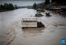
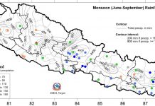
According to meteorologist Raju Pradhananga of Department of Hydrology and Metrology, the monsoon trough frequently moves southward and northward, and brings heavy rainfall when it is stationary. The monsoon trough which had shifted towards south from Nepal some days back, again moved up to Nepal on Monday, increasing the chances of moderate to heavy rainfall in almost all parts of the country till Wednesday.
With the possibility of widespread rain, precipitation is likely to occur in hilly regions and rises in waters level in the rivers flowing across the Chure and hills. On such conditions, air and transportation services might get disrupted. Rainfall measuring 50 to 100 millimeters is termed as the heavy rainfall while it is measured as the very heavy rainfall when it exceeds 100 mm. This year, the maximum rain in the Kathmandu Valley was measured on July 13.
The Valley witnessed the 104 mm rain on that day. Flashfloods are predicted from some small rivers in the Tarai and hilly region on Tuesday and Wednesday as level of waters in the Kankai, Kamala and Bagmati rivers and some tributaries is likely to go up in this period.
People residing on the settlements near banks of such rivers are requested to remain watchful and take preparedness and response if necessary. Tonight, generally to totally cloudy condition will prevail in the hilly and central regions and partially cloudy weather over the western region. There are chances of rainfall in almost all parts of eastern and central regions and at some places of western region, Department said. RSS


