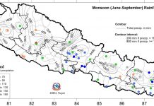
The Division has stated that it will take three or four days more for monsoon to be fully active since the low pressure trough is still located in central India. Meteorologist at the Division, Raju Pradhananga said it will take three or four days for the low pressure system to gradually move towards Nepal.
Only light and brief rainfall is occurring at present due to the weak monsoon and there is no possibility of heavy rain immediately, according to the Division. Although light rainfall has been taking place towards the morning and evening in Kathmandu Valley, intense sun in the midday and cloudy condition continue to prevail in the afternoon. Alteration of partly cloudy sky and sunshine has increased heat in the Valley.
The maximum temperature in Kathmandu Valley hovers around 31 to 32.5 degrees Celsius since the last three days. The maximum temperature today is 31.8 degrees Celsius. Before this the Valley recorded the highest maximum temperature of 33.5 degrees Celsius, this year’s maximum temperature, on June 14.
The maximum temperature in Dipayal, Dhangadhi and Nepalgunj today was 37.5 degrees Celsius. Weather forecast for coming three days The weather will remain generally cloudy throughout the country with chances of light to moderate rainfall in some places of the country tonight.
Similarly, partly to generally cloudy conditions will prevail across the country with the possibility of light rain accompanied by thunder in many places tomorrow. There are chances of heavy rainfall in one or two places of central and western region.
Likewise, the weather will remain generally cloudy throughout the country with chances of light to moderate rainfall in few places on Friday, the Division said. Generally monsoon enters the country on June 10 but this year it arrived 12 days late. The period between June 10 to September 23 is taken as the active monsoon period. RSS


